


WALK TO SALKANTAY
Salcantay located in the Cordillera Vilcabamba, department of Cusco, rises to 6271 meters above sea level.
The Salkantay is the Apu and tutelary mountain of Cusco.
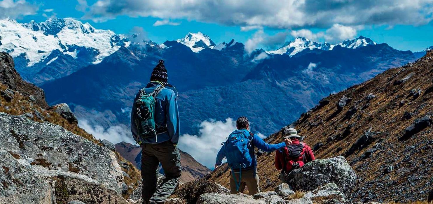
To get to it, you will cross beautiful Andean landscapes, open to 5,000 meters. and the possibility of observing Condors and Alpacas in their natural habitat. You can take baths in natural hot springs from the depths of the earth, different fruit plants and a variety of orchids.
The Cordillera de Vilcabamba, where the Salcantay massif is located, is a beautiful and lonely area. Dominated by the same Apu Salcantay, it has numerous high elevation peaks, such as Tucarhuay (5,910 masl), Verónica (5,682 masl) and Huacayhuilca (5,361 masl), among others.
All of them are visible from the Puyupatamarca area during the Inca Trail to Machu Picchu. Geography is difficult and whimsical around the edge of this attractive mountain complex. The Salkantay is surrounded by deep valleys and ravines, which makes its route interesting but at the same time exhausting.
Although the difficulty of this Trek is slightly higher than that of the Inca Trail, it is not a high level Trek either. Indeed, it is longer (5 days instead of 4), higher, more wild but that is also where your interest lies.
This Trek does not disappoint the most demanding or lovers of nature, walks, emotions; those same emotions that make you feel invulnerable, only in the world, on the roof of the world, in a few words … feel alive !.
The Salkantay Trail is one of the many options that exist to get to Machu Picchu.
The Salkantay Way you can do it with agency or by your account. Yes, I am always avoiding the agencies to the fullest. In this case, I do not trust myself.
Imagine getting tired, having to set up camp, cooking, not to mention having to carry all the luggage during the walk, which is difficult in itself without anything on top. In addition, the changing mountain climate, from one minute to another You can turn around radically. Or if height takes your toll in the middle of the mountain and you can not continue.
In those cases, it is necessary to have people who know what they are doing. Without wanting to be drastic, but with the mountain is not played, and that, can be the difference between telling the story or tell your story.
That’s why I’ve always opted to do it with an agency, and until I have more experience in the mountains, it will continue to be that way.

On the way to Abra Salkantay
With aching hands, we begin the path.
I tried to gain speed to warm up, but there was no way.
With the sun still hidden behind the mountains, there was no way to get me out of the cold.
The goal was to reach the Abra Salkantay. An Abra, in this case, is used to refer to a step, the place by which it is possible to cross walking between the mountains.

Salkantay Pampa
That first part of the road is easy, and ends in a valley called Salkantay Pampa at 4,100 meters above sea level.
To which we arrived at 8:15 am, about 45 minutes after leaving the camp.
Yes, it has rises, but it is not anything that smooth walking can not be done.
In Salkantay Pampa there is a place to stock up, which you will find all along the way.
From Salkantay Pampa, the road divides in two.
For one, less steep, is that the travelers go.
And on the other go the muleteers with the mules carrying the luggage … in an endless climb, yes yes, endless, that road seems to take you straight to the gates of heaven.
Suyroqocha
After that climb, we arrive at Soirococha or Suyroqocha, at 4,480 meters above sea level, at 9:30 am.
Place with bathrooms and stand to stock up on water and food, before the last climb.
After resting for a while, we went for the last climb, to the Abra de Salkantay, the highest point of the trip at 4,630 meters of altitude.
That place is also known as Salkantay Pass.
From Suyroqocha it is one kilometer more until the Abra Salkantay, always upwards.
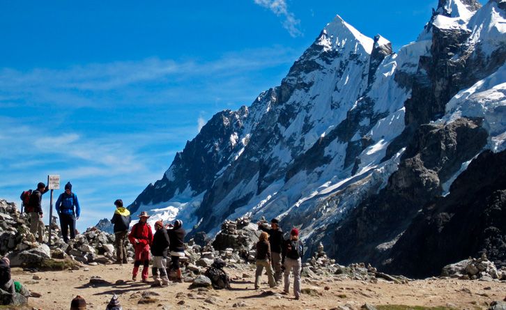
Abra Salkantay
Before 11:00 am we were already enjoying the highest point of the Salkantay Trail … the most difficult, it had happened.
From that point, we had the most spectacular view, with Salkantay right in front of us in all its splendor.
As imposing as these mountains, it is understood why the Incas considered them gods.
In the Abra de Salkantay, we missed our time.
Photo goes, photo comes, listen to the stones fell down the mountain, as the ice broke and it was cracking … made the minutes pass us without realizing it. So at 12:30 we were taking the road again, heading to camp 2, where lunch was waiting for us.
The issue is that we were very far away, and we had been late. Besides, we would not sleep in that camp. It was just for lunch. From there, we had to continue to camp 3, and the problem was that it would grab us the night.
For the terrain, Abra Salkantay is considered the most difficult point, but for me, the difficult thing would come after lunch.

Huayracmachay
From the Abra Salkantay, we leave behind the imposing mountain and return to the road … everything downhill
In principle good news, but the knees feel much more downhill than the ups. The road to camp 2 was long, quite long, but easy in all. Downhill, losing height quickly, and with spectacular scenery.
We made it soft, quiet, and stopping to rest. Approximately at 3:00 p.m. we were in the camp. There was not much time, fast lunch and leave prepared in case we were caught by the night.
At 16:30 we left for camp 3 where we would spend the night. Upon returning to the road, one of the most curious places is quickly reached. It is at the height of Huayracmachay, a few minutes from camp 2.
In Huayracmachay, we were at 3,853 meters above sea level, far from the 4,600 from the Abra Salkantay or the 3,912 from camp 1 in Soraypampa. At that point, at 3,800 meters, we saw the perfect line where the landscape begins to change. Behind is the inhospitable landscape of the rocky mountains, to give way to the high jungle.
Which, kilometers later, and some thousands of meters less in height, will be transformed into the Amazon.
Chawllay
With a landscape completely changed from one minute to another, surrounded by vegetation, and feeling the passage from a dry climate to a humid climate, we continue towards Chawllay, where Camp 3 is located.
Much of the way, he had no difficulty. Nice to walk, surrounded by the Andean flora and downhill, After 18:00 the sun began to leave us, and we grabbed the night. Total darkness.
And I, I felt that was the hardest part of the whole trip. Walking at night, with a flashlight that illuminated very little, was complicated. Adding the dust that rose at each step, which made it even harder to see the stones of the road.
Not counting, that always walking to the edge of the precipice. But, above all, it was in this part of the descent that my knees started to bother me.
We will have been an hour walking in the night … it was the only leg of the trip in which I could not see the time to end, I was looking forward to the camp. And beyond the fatigue, we did it without any inconvenience, arriving at 19:00.